Victory in the West: A maid among ruins

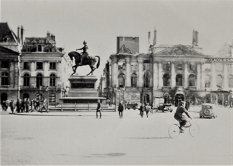
Standing alone among the ruins of Orléans, the statue of the 15th century heroine Jeanne d’Arc attract the curious gaze of the German occupiers. The saint couldn’t save France this time, but her value as a symbol would inspire the Free French forces that would return four years later to liberate their country. On 17 June, 1940, the Germans captured Orléans, which would remain under German rule for over four years.

orleans_2

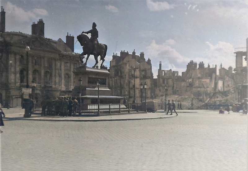
Burnt-out buildings and collapsed ruins line Place du Martroi after the 36 hours of shelling that Orléans had to endure. Unlike Paris, the city wasn’t declared an open city. The goal was to deny the Germans the bridges that cross the river Loire. The bombardment set off fires that ravaged the city, but thanks to favorable winds, the flames didn’t reach some of the most important historical buildings, like the cathedral.

orléans_now

This is what the Place du Martroi looks like today. The buildings which were gutted by fire in 1940 have been restored to their former glory since many years. The bridges which were destroyed in 1940 were rebuilt, only to be bombed to pieces by the Allies in 1944 in preparation of D-Day. Many communication hubs were attacked in order to delay German reinforcements bound for Normandy, and many thousands of French civilians were killed in the raids.

orleans_col

Views like this became all too common all over Europe. In some cases, the sites of destroyed buildings (known as “bomb lots”) didn’t see new houses until the 1970s, and in many towns and cities, surviving buildings still show the pockmarks of bullets and shrapnel, witnesses of the most destructive war ever to ravage Europe.

Victory in the West: Signs of the new masters

A Luftwaffe NCO stands outside a church in Lille, northern France. It’s some time after the Germans captured the city, and the road signs are there to show the way for the new masters. It took the Wehrmacht two and a half weeks to reach Lille, but strategic points in the city had already experienced the attention of Luftwaffe bombers. The German army advanced rapidly, occupying Luxembourg and Belgium before eventually reaching Lille on 27 May. After three Panzer divisions attacked from west of the Deûle river, French and British soldiers withdrew from the city, leaving only a few pioneer regiment units, eighty administrative clerks, and a thousand Tirailleurs Sénégalais (colonial troops from Senegal) entrenched in the Citadel of Lille. Though otherwise ill-equipped, the Senegalese regiment’s armored vehicles allowed them to resist the siege for four days.

To prevent strategic resources from falling into German hands, the British destroyed the Boitelle telephone exchange and burned a stockpile of military equipment that couldn’t be evacuated. On the morning of 28 May, German patrols defeated pockets of resistance around the Rue de Solférino, the Rue Nationale, and the Haute-Deûle. Field headquarters were set up in the Grand’Place (after the war renamed Place du Général-de-Gaulle). On 30 May, there was fighting in the western suburb of Lomme, and on 31 May, the last remaining resistance on the Avenue de Dunkerque in Lambersart and in the Citadel laid down their arms.

The Battle of Lille officially ended on 1 June, when captive French soldiers were marched through the city streets and the Grand’Place. The final death toll was 174, including 15 civilians, 128 French soldiers, 1 British soldier, and 30 German soldiers. For a battle for a city, those losses were surprisingly light. Two bridges and 220 buildings were destroyed, including the Place de Tourcoing and the buildings surrounding the Porte de Béthune.

Lille

By looking at the distances on the signs, I figured out that the photo was taken in Lille. As one sign pointed towards “Stadtmitte” (“City center”), it was clearly not right in the center of Lille. Google Maps was consulted, and by using the street view option, I checked a few churches in the most likely area. I found the right one: Eglise du Sacre Cœur on the intersection of Rue Nationale and Rue de Solférino. This area was fought over on 28 May 1940, but there’s nothing that reminds us of that today.

Victory in the West: the Fall of Péruwelz

French prisoners of war march across the Grand-Place of Péruwelz, on their way to a PoW camp. There will be almost 5 years before they are liberated. The Belgian town on the border to France fell in German hands on 20 May, 1940. Ten days earlier, the citizens of Péruwelz had heard German combat aircraft fly over the town and anti-aircraft guns firing in the hours just before dawn. The next day, French motorized troops arrived to the area. A couple days later (13 May), colonial troops in the shape of Senegalese infantry passed through the town on the way to the front. Next day, refugees crowded the streets, fleeing from the battles to the east and north. The French had closed the border, leaving the refugees stranded.

In the afternoon of 16 May, three German bombers attacked the town, dropping 27 50 kg bombs. They killed four locals and caused fires and material damage. It’s unclear whether any refugees were killed. The reason for the raid was explained a couple of weeks later, when a crewmember of one of the attacking German bombers visited Péruwelz. He told the locals that they had been ordered to bomb the town in order to make the townspeople flee and take to the roads, clogging the routes taken by French army units and delaying their movements. This tactic of terror bombing was repeated in many other places, and contributed to the difficulties that the Belgian, French and British troops experienced. The next day, the director of the local branch of the National Bank evacuated the cash from the bank.

On 19 May, the residents of Péruwelz were advised to stay at home. Some houses were looted of valuables and foodstuffs, presumably by refugees. The next day, the first German soldiers appeared. A retreating French soldier was killed by a reconnaissance motorcycle combination. The townspeople observed that the Germans were very polite towards the Belgian civilians. A German artillery unit took up positions outside the town and began shelling French fortifications on the other side of the border. On 25 May, the  Germans installed a Kommandantur as a part of the occupation regime. Three days later, Belgium surrendered.

The photo above was taken at the Grand-Place in Péruwelz, by the corner of Rue Astrid. The picture below shows the location today. Rue Astrid is named in memory of Queen Astrid, the Swedish-born princess who married Prince Leopold, later King Leopold III. She was much beloved by the Belgians, but she got to be their monarch for just 1½ years, as the young Queen was killed in a car accident in 1935. The current King of Belgium, Philippe, is the grandson of Queen Astrid.

Grand-Place_Péruwelz

Last stand in Lille

The aftermath of the Battle of France… In an unknown French city, the burned-out wreck of a French AMC Schneider P 16 sits in the street, knocked out by German gunfire.

The AMC P 16 was a half-tracked armored vehicle intended for infantry support and reconnaissance, designed in 1924 and produced between 1928 and 1931. Just 100 were built before better designs became available. It was armed with a short 37 mm gun and a machine gun. The crew numbered three men, and the speed on good roads was 50 km/h. By the time for the Battle of France, just over 50 vehicles were operational. Several suffered mechanical breakdowns, and any surviving AMCs weren’t pressed into German service. There are no known surviving AMC P 16s.

AMCP16 - kopia

What appears to be the skulls of two crew members can be seen just to the right of center in the photo. It was the worst fear of armored crews to be trapped in a burning vehicle. If they were “lucky”, they died instantly when the vehicle was hit; if not, they could be wounded and conscious, unable to get out in time while the fuel started to burn and the ammunition to cook off.

Did I write “unknown French city”? Well, here’s where the Internet comes in… I went to my to-go site when it comes to French armored vehicles, Chars-Francais.net, where I found five other photos of the vehicle. Four show the wreck, and the other while the vehicle was still in running order. The most valuable information was the vehicle’s serial number: 37127. I posted a question on Axis History Forum about the possible location of the wreck, and within hours I had received a reply. There was a discussion on this very vehicle on a French forum, which yielded some very specific information…

The #37127 was part of the reconnaissance unit of 4th Motorized Infantry Division, more specifically the 3rd platoon of the 1st squadron of 4é GRDI (4é Groupe de Reconnaissance de Division d’Infantrie, 1er escadron, 3ème peloton). The division was mobilized on 2 September 1939, and saw combat in the Battle of France. Most of the division was captured in Lille and Dunkirk. In Lille, it was pitted against the 7. Infanterie-Division, and on Thursday the 30th of May, 1940, around 14:30, the armored car was knocked out in Avenue de Dunkerque in the Lille suburb Lomme, probably by a German Pak 36 3.7 cm anti-tank gun. It is probable that none of the crew got out alive.

lille472 Avenue de Dunkerque, Lomme, Lille, Hauts-de-France

This is what the spot where #37127 was destroyed looks like today. Thanks to Axis History Forum member Loïc for pointing me to the French forum discussion on this vehicle, and the great research made by its members.

After the battle

Tallinn, Estonia: a set of photos, contrasting 1941 with 2017. Some years ago, I acquired a series of photos taken by a German soldier in the summer of 1941. He probably served in the 291. Infanterie-Division, judging by other photos indicating the approach to Tallinn. A few of the photos were taken in the city after the occupying Red Army had been thrown out, and were probably from early September that year. I searched for the locations where the photographer had stood almost 76 years ago and took new photos.

Top: view of Vabaduse väljak (“Freedom Square”), from outside Hotel Palace. In Soviet times, this was the “Victory Square”, before that there were city blocks.

Center: the 15th century artillery tower Kiek in de Kök, which is Low German: Peep into the Kitchen, alluding to the view it offers of the neighbors…

Bottom: view from the northern part of the Toompea (“Cathedral Mountain”, Tallinn’s “high town”, facing north-east. Here, I couldn’t access the exact spot the soldier stood in, but this was close enough.

I hope you’ll enjoy these then-and-now photos. Those of you who would like to take a closer look at Tallinn: do it! It’s a beautiful city, well worth a visit.